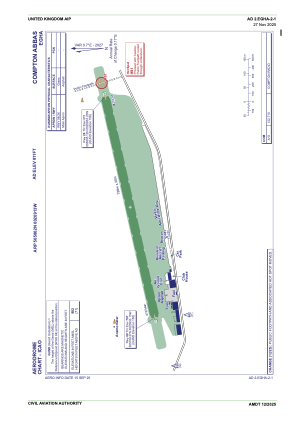


EGHA - Compton Abbas
Located in Shaftesbury, United Kingdom
ICAO - EGHA, IATA -
Data provided by AirmateGeneral information
Coordinates: N50°58'2" W2°9'13"
Elevation is 811 feet MSL.
View others Airports in England
Operational data
Special qualification required
Current time UTC:
Current local time:
Weather at : EGHH - Bournemouth ( 30 km )
METAR: EGHH 251020Z 26008KT 210V300 9999 FEW028 BKN043 10/03 Q1005
TAF: TAF EGHH 250755Z 2509/2518 26005KT 9999 FEW035 TEMPO 2510/2518 6000 SHRA PROB30 TEMPO 2512/2518 4000 +SHRA BKN014
Communications frequencies: [VIEW]
Runways:
| RWY identifier | QFU | Length (ft) | Width (ft) | Surface | LDA (ft) |
| 08 | 77° | 2635 | 98 | Grass | |
| 26 | 257° | 2635 | 98 | Grass |
Airport contact information
Address: Shaftesbury United Kingdom
