


E06 - Lea County/Zip Franklin Meml
Located in Lovington, United States
ICAO - E06, IATA -
Data provided by AirmateGeneral information
Coordinates: N32°57'14" W103°24'32"
Elevation is 3979 feet MSL.
Magnetic variation is 07° East View others Airports in New Mexico
Operational data
Special qualification required
Current time UTC:
Current local time:
Weather at : KHOB - Lea County Rgnl ( 35 km )
METAR: KHOB 070215Z AUTO 23017G23KT 10SM CLR 26/M14 A2974 RMK AO2
TAF: KHOB 062320Z 0700/0724 25020G30KT P6SM SKC FM070500 30011KT P6SM SKC FM071800 22019G27KT P6SM SKC
Communications frequencies: [VIEW]
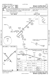
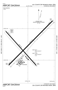
Runways:
| RWY identifier | QFU | Length (ft) | Width (ft) | Surface | LDA (ft) |
| 03 | 45° | 6001 | 75 | ASPH | |
| 21 | 225° | 6001 | 75 | ASPH | |
| 12 | 138° | 4409 | 60 | ASPH | |
| 30 | 318° | 4409 | 60 | ASPH |
Airport contact information
Address: Lovington United States