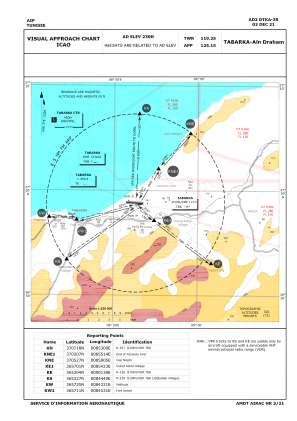


DTKA - Tabarka/Ain Draham
Located in Tabarka, Tunisia
ICAO - DTKA, IATA - TBJ
Data provided by AirmateGeneral information
Coordinates: N36°58'48" E8°52'37"
Elevation is 230 feet MSL.
View others Airports in Jendouba Governorate
Operational data
Special qualification required
Current time UTC:
Current local time:
Weather
METAR: DTKA 190400Z 26010KT 250V320 9999 SCT020 SCT030 11/08 Q1017 NOSIG
TAF: TAF DTKA 190300Z 1904/1913 28010KT 9999 SCT020 PROB40 TEMPO 1904/1913 27020G30KT TSRA FEW023CB
Communications frequencies: [VIEW]
Runways:
| RWY identifier | QFU | Length (ft) | Width (ft) | Surface | LDA (ft) |
| 09 | 93° | 9416 | 148 | ASP | |
| 27 | 273° | 9416 | 148 | ASP |
Airport contact information
Address: Tabarka Tunisia