


CYYF - Penticton
Located in Penticton, Canada
ICAO - CYYF, IATA - YYF
Data provided by AirmateGeneral information
Coordinates: N49°27'47" W119°36'8"
Elevation is 1130 feet MSL.
Magnetic variation is 18° East View others Airports in British Columbia
Operational data
Special qualification required
Current time UTC:
Current local time:
Weather
METAR: CYYF 252100Z 14008KT 15SM -SHRA FEW035 OVC075 12/06 A2977 RMK CF1AC7 SLP086
TAF: TAF CYYF 251840Z 2519/2607 17012KT P6SM SCT015 BKN060 TEMPO 2519/2521 5SM -RA BR BKN015 FM252100 18010KT P6SM -RA SCT025 OVC050 TEMPO 2521/2603 4SM -SHRA BR BKN025 FM260300 VRB03KT P6SM -RA SCT015 OVC025 TEMPO 2603/2607 2SM -RA BR BKN012 RMK NXT FCST BY 260100Z
Communications frequencies: [VIEW]
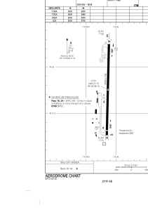
Runways:
| RWY identifier | QFU | Length (ft) | Width (ft) | Surface | LDA (ft) |
| 16 | 181° | 6000 | 148 | ASPH | 6000 |
| 34 | 1° | 6000 | 148 | ASPH | 5700 |
Airport contact information
Address: Penticton Canada
