


CYXH - Medicine Hat
Located in , Canada
ICAO - CYXH, IATA - YXH
Data provided by AirmateGeneral information
Coordinates: N50°1'8" W110°43'14"
Elevation is 2351 feet MSL.
Magnetic variation is 12.9367° East View others Airports in Alberta
Operational data
Special qualification required
Current time UTC:
Current local time:
Weather
METAR: CYXH 261500Z 36008KT 30SM FEW210 BKN250 09/M02 A2984 RMK CI2CS5 SLP114
TAF: TAF CYXH 261140Z 2612/2624 36008KT P6SM FEW100 BKN200 FM261500 02012KT P6SM SCT080 BKN120 BKN200 RMK FCST BASED ON AUTO OBS. NXT FCST BY 261800Z
Communications frequencies: [VIEW]
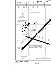
Runways:
| RWY identifier | QFU | Length (ft) | Width (ft) | Surface | LDA (ft) |
| 09 | 107° | 2850 | 100 | ASPH | 2850 |
| 27 | 287° | 2850 | 100 | ASPH | 2850 |
| 03 | 45° | 5003 | 150 | ASPH | 5003 |
| 21 | 225° | 5003 | 150 | ASPH | 5003 |
Airport contact information
Address: Canada
