


CYWJ - Deline
Located in , Canada
ICAO - CYWJ, IATA - YWJ
Data provided by AirmateGeneral information
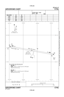
Coordinates: N65°12'40" W123°26'11"
Elevation is 702 feet MSL.
Magnetic variation is 20.6566° East View others Airports in Northwest Territories
Operational data
Special qualification required
Current time UTC:
Current local time:
Weather
METAR: CYWJ 252100Z 13007KT 20SM BKN030 OVC080 M05/M09 A3004 RMK SC7AC1 SLP195
TAF: TAF AMD CYWJ 251908Z 2519/2523 32007KT P6SM OVC025 RMK NXT FCST BY 261400Z
Communications frequencies: [VIEW]
Runways:
| RWY identifier | QFU | Length (ft) | Width (ft) | Surface | LDA (ft) |
| 08 | 100° | 3933 | 99 | GRAVE | 3933 |
| 26 | 280° | 3933 | 99 | GRAVE | 3933 |
Airport contact information
Address: Canada