


CYQH - Watson Lake
Located in Watson Lake, Canada
ICAO - CYQH, IATA - YQH
Data provided by AirmateGeneral information
Coordinates: N60°6'59" W128°49'21"
Elevation is 2255 feet MSL.
Magnetic variation is 25° East View others Airports in Yukon Territory
Operational data
Special qualification required
Current time UTC:
Current local time:
Weather
METAR: CYQH 192300Z 14003KT 090V160 40SM BKN250 13/M14 A3027 RMK CI5 SLP283
TAF: TAF CYQH 191740Z 1918/2006 VRB03KT P6SM SCT250 RMK NXT FCST BY 200000Z
Communications frequencies: [VIEW]
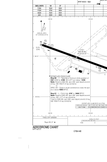
Runways:
| RWY identifier | QFU | Length (ft) | Width (ft) | Surface | LDA (ft) |
| 09 | 110° | 5504 | 150 | ASPH | 5504 |
| 27 | 290° | 5504 | 150 | ASPH | 5504 |
| 08 | 8° | 5500 | 150 | ASPH | |
| 26 | 265° | 5500 | 150 | ASPH |
Airport contact information
Address: Watson Lake Canada
