


CYPT - Pelee Island
Located in Pelee Island, Canada
ICAO - CYPT, IATA - YPT
Data provided by AirmateGeneral information
Coordinates: N41°46'42" W82°40'41"
Elevation is 572 feet MSL.
Magnetic variation is -07° East View others Airports in Ontario
Operational data
Special qualification required
Current time UTC:
Current local time:
Weather at : KPCW - Erie-Ottawa Intl ( 33 km )
METAR: KPCW 261415Z AUTO 11006KT 10SM CLR 11/02 A3026 RMK AO2
Communications frequencies: [VIEW]
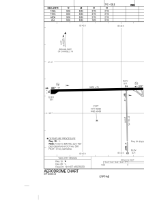
Runways:
| RWY identifier | QFU | Length (ft) | Width (ft) | Surface | LDA (ft) |
| 10 | 90° | 3303 | 75 | ASPH | 3303 |
| 28 | 270° | 3303 | 75 | ASPH | 3303 |
| 01 | 360° | 2113 | 15 | GRAVE | 1813 |
| 19 | 180° | 2113 | 15 | GRAVE | 2113 |
| 09 | 0° | 3300 | 75 | ASPH | |
| 27 | 0° | 3300 | 75 | ASPH | |
| 18 | 0° | 1500 | 20 | GRAVEL | |
| 36 | 0° | 1500 | 20 | GRAVEL |
Airport contact information
Address: Pelee Island Canada