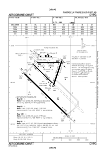


CYPG - Portage La Prairie
Located in Portage, Canada
ICAO - CYPG, IATA - YPG
Data provided by AirmateGeneral information
Coordinates: N49°54'10" W98°16'29"
Elevation is 884 feet MSL.
Magnetic variation is 06° East View others Airports in Manitoba
Operational data
Special qualification required
Current time UTC:
Current local time:
Weather
METAR: CYPG 262200Z 12007KT 3SM -RA BR FEW008 BKN026 OVC037 09/08 A2970 RMK SF2SC3SC3 DENSITY ALT 716FT LAST OBS /NEXT 291100 UTC SLP062
TAF: TAF CYPG 261741Z 2618/2706 16010KT 5SM -RA SCT012 OVC025 TEMPO 2618/2702 1 1/2SM SHRA BR BKN012 OVC025 BECMG 2622/2624 10005KT FM270200 02008KT 5SM -RA BR SCT015 OVC050 RMK NXT FCST BY 270000Z
Communications frequencies: [VIEW]
Runways:
| RWY identifier | QFU | Length (ft) | Width (ft) | Surface | LDA (ft) |
| 13L | 134° | 3120 | 98 | ASPH | 3120 |
| 31R | 314° | 3120 | 98 | ASPH | 3120 |
| 09 | 89° | 2670 | 98 | ASPH | 2670 |
| 27 | 269° | 2670 | 98 | ASPH | 2670 |
| 02 | 19° | 3033 | 150 | ASPH | 3033 |
| 20 | 199° | 3033 | 150 | ASPH | 3033 |
| 13R | 134° | 7000 | 200 | ASPH | 7000 |
| 31L | 314° | 7000 | 200 | ASPH | 7000 |
Airport contact information
Address: Portage Canada