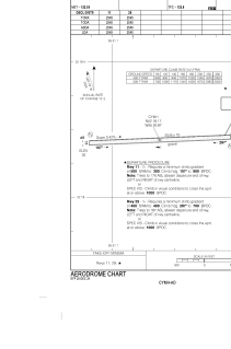


CYMH - Marys Harbour
Located in , Canada
ICAO - CYMH, IATA - YMH
Data provided by AirmateGeneral information
Coordinates: N52°18'10" W55°50'52"
Elevation is 35 feet MSL.
Magnetic variation is -21.0425° East View others Airports in Newfoundland and Labrador
Operational data
Special qualification required
Current time UTC:
Current local time:
Weather
METAR: CYMH 242008Z AUTO 17015G20KT 9SM -RA OVC071 03/M03 A2996 RMK SLP148
TAF: TAF CYMH 241940Z 2420/2503 10015KT P6SM BKN080 TEMPO 2420/2423 P6SM -RA FM242300 10015KT P6SM SCT009 OVC060 TEMPO 2423/2501 4SM -RA BR BKN009 FM250100 06012KT 1SM -SN OVC007 TEMPO 2501/2503 3SM -PL -FZRA BR SCT007 OVC010 RMK FCST BASED ON AUTO OBS. NXT FCST BY 250900Z
Communications frequencies: [VIEW]
Runways:
| RWY identifier | QFU | Length (ft) | Width (ft) | Surface | LDA (ft) |
| 11 | 88° | 2545 | 75 | GRAVE | 2545 |
| 29 | 268° | 2545 | 75 | GRAVE | 2545 |
Airport contact information
Address: Canada