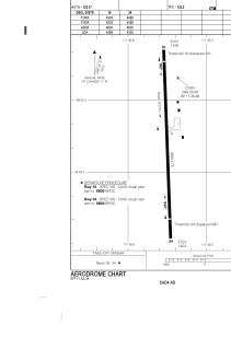


CAD4 - Trail
Located in , Canada
ICAO - CAD4, IATA - YZZ
Data provided by AirmateGeneral information
Coordinates: N49°3'20" W117°36'33"
Elevation is 1427 feet MSL.
Magnetic variation is 15.555° East View others Airports in British Columbia
Operational data
Special qualification required
Current time UTC:
Current local time:
Weather at : CYCG - West Kootenay Regional ( 27 km )
METAR: CYCG 261600Z 19004KT 8SM FEW005 SCT031 OVC054 11/09 A2980 RMK SF2SC2SC4 SLP099
TAF: TAF AMD CYCG 261533Z 2615/2703 VRB03KT P6SM -RA FEW001 SCT015 BKN040 TEMPO 2615/2620 3SM -RA BR FEW001 BKN015 OVC040 FM262000 33006KT P6SM SCT030 BKN060 TEMPO 2620/2703 5SM -SHRA BR BKN030 OVC060 RMK NXT FCST BY 261900Z
Communications frequencies: [VIEW]
Runways:
| RWY identifier | QFU | Length (ft) | Width (ft) | Surface | LDA (ft) |
| 16 | 178° | 4001 | 75 | ASPH | 4001 |
| 34 | 358° | 4001 | 75 | ASPH | 4001 |
Airport contact information
Address: Canada