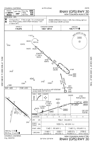
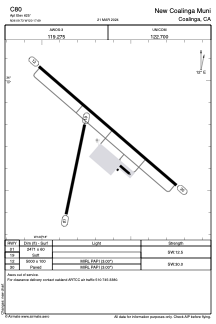


C80 - New Coalinga Muni
Located in Coalinga, United States
ICAO - C80, IATA -
Data provided by AirmateGeneral information
Coordinates: N36°9'44" W120°17'41"
Elevation is 625 feet MSL.
Magnetic variation is 15° East View others Airports in California
Operational data
Special qualification required
Current time UTC:
Current local time:
Weather at : KNLC - Lemoore Nas (Reeves Fld) ( 36 km )
METAR: KNLC 060056Z 35014KT 10SM FEW060 FEW200 18/00 A3004 RMK AO2 SLP172 RH/28 T01830000
TAF: TAF KNLC 0523/0623 33015G20KT 9999 FEW050 QNH3000INS TEMPO 0519/0601 34017G24KT FM060300 33009KT 9999 SKC QNH3002INS FM060900 VRB06KT 9999 SKC QNH2998INS FM062100 28009G18KT 9999 FEW050 QNH3000INS TX20/0623Z TN06/0612Z FS30186
Communications frequencies: [VIEW]
Runways:
| RWY identifier | QFU | Length (ft) | Width (ft) | Surface | LDA (ft) |
| 01 | 12° | 2471 | 60 | OTHER | |
| 19 | 192° | 2471 | 60 | OTHER | |
| 12 | 131° | 5000 | 100 | ASPH | |
| 30 | 311° | 5000 | 100 | ASPH |
Airport contact information
Address: Coalinga United States