


B10 - Bowman Fld
Located in Livermore Falls, United States
ICAO - B10, IATA -
Data provided by AirmateGeneral information
Coordinates: N44°24'36" W70°8'46"
Elevation is 324 feet MSL.
Magnetic variation is -18° East View others Airports in Maine
Operational data
Special qualification required
Current time UTC:
Current local time:
Weather at : KAUG - Augusta State ( 29 km )
METAR: KAUG 291753Z AUTO 35010G19KT 10SM CLR 18/03 A3001 RMK AO2 SLP164 T01830028 10183 20100 58006
TAF: KAUG 291720Z 2918/3018 34012G20KT P6SM FEW250 FM292300 35005KT P6SM SCT200 FM301400 36005KT P6SM BKN060
Communications frequencies: [VIEW]
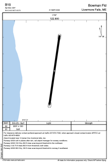
Runways:
| RWY identifier | QFU | Length (ft) | Width (ft) | Surface | LDA (ft) |
| 02 | 8° | 2201 | 120 | GRASS | |
| 20 | 188° | 2201 | 120 | GRASS |
Airport contact information
Address: Livermore Falls United States