


9M8 - Sheridan-Grant County Rgnl
Located in Sheridan, United States
ICAO - 9M8, IATA -
Data provided by AirmateGeneral information
Coordinates: N34°19'39" W92°21'5"
Elevation is 236 feet MSL.
Magnetic variation is 00° East View others Airports in Arkansas
Operational data
Special qualification required
Current time UTC:
Current local time:
Weather at : KPBF - Pinebluff Rgnl/Grider Fld ( 42 km )
METAR: KPBF 261853Z AUTO 16023G31KT 10SM BKN035 28/18 A2990 RMK AO2 PK WND 17031/1852 SLP122 T02780178
TAF: KPBF 261931Z 2620/2718 16011G26KT P6SM SCT025 BKN035 FM262300 18010G19KT P6SM -SHRA VCTS SCT025CB OVC080 TEMPO 2700/2704 VRB15G25KT 2SM TSRA BR OVC015CB FM270700 16010KT P6SM VCSH OVC015 FM271200 16009KT P6SM OVC025
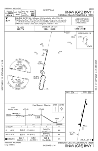
Communications frequencies: [VIEW]
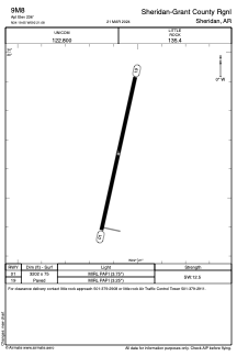
Runways:
| RWY identifier | QFU | Length (ft) | Width (ft) | Surface | LDA (ft) |
| 01 | 12° | 3202 | 75 | ASPH | |
| 19 | 192° | 3202 | 75 | ASPH |
Airport contact information
Address: Sheridan United States