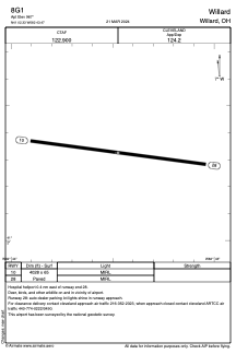


8G1 - Willard
Located in Willard, United States
ICAO - 8G1, IATA -
Data provided by AirmateGeneral information
Coordinates: N41°2'20" W82°43'28"
Elevation is 967 feet MSL.
Magnetic variation is -06° East View others Airports in Ohio
Operational data
Special qualification required
Current time UTC:
Current local time:
Weather at : KMFD - Mansfield Lahm Rgnl ( 30 km )
METAR: KMFD 050252Z 13006KT 10SM FEW013 BKN022 BKN080 19/17 A2994 RMK AO2 SLP132 T01890172 58000
TAF: KMFD 042346Z 0500/0524 14008KT P6SM BKN060 FM050400 15009KT 5SM BR VCSH OVC015 FM050600 19009KT P6SM OVC008 FM051300 23009KT P6SM SCT035 FM052200 30009KT P6SM BKN035
Communications frequencies: [VIEW]
Runways:
| RWY identifier | QFU | Length (ft) | Width (ft) | Surface | LDA (ft) |
| 10 | 97° | 4028 | 65 | ASPH | |
| 28 | 277° | 4028 | 65 | ASPH |
Airport contact information
Address: Willard United States