


80V - Medicine Bow
Located in Medicine Bow, United States
ICAO - 80V, IATA -
Data provided by AirmateGeneral information
Coordinates: N41°53'2" W106°10'58"
Elevation is 6658 feet MSL.
Magnetic variation is 12° East View others Airports in Wyoming
Operational data
Special qualification required
Current time UTC:
Current local time:
Weather at : KSAA - Shively Fld ( 73 km )
METAR: KSAA 201555Z AUTO 30008KT 10SM BKN120 01/M05 A3020 RMK AO2
Communications frequencies: [VIEW]
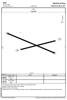
Runways:
| RWY identifier | QFU | Length (ft) | Width (ft) | Surface | LDA (ft) |
| 06 | 75° | 2680 | 50 | OTHER | |
| 24 | 255° | 2680 | 50 | OTHER | |
| 10 | 113° | 3170 | 80 | OTHER | |
| 28 | 293° | 3170 | 80 | OTHER |
Airport contact information
Address: Medicine Bow United States