


80G - Tri-City
Located in West Lafayette, United States
ICAO - 80G, IATA -
Data provided by AirmateGeneral information
Coordinates: N40°14'52" W81°44'10"
Elevation is 844 feet MSL.
Magnetic variation is -06° East View others Airports in Ohio
Operational data
Special qualification required
Current time UTC:
Current local time:
Weather at : KCDI - Cambridge Muni ( 33 km )
METAR: KCDI 240855Z AUTO 24003KT 10SM SCT017 SCT023 SCT029 11/10 A2992 RMK AO2 T01060095
Communications frequencies: [VIEW]
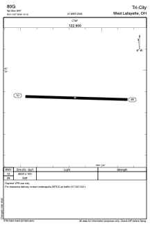
Runways:
| RWY identifier | QFU | Length (ft) | Width (ft) | Surface | LDA (ft) |
| 10 | 92° | 3000 | 100 | GRASS | |
| 28 | 272° | 3000 | 100 | GRASS |
Airport contact information
Address: West Lafayette United States