


73S - Willard Fld
Located in Tekoa, United States
ICAO - 73S, IATA -
Data provided by AirmateGeneral information
Coordinates: N47°14'8" W117°2'38"
Elevation is 2520 feet MSL.
Magnetic variation is 19° East View others Airports in Washington
Operational data
Special qualification required
Current time UTC:
Current local time:
Weather at : KSFF - Felts Fld ( 54 km )
METAR: KSFF 240453Z AUTO 06003KT 10SM CLR 09/M02 A2990 RMK AO2 SLP125 T00891017
TAF: KSFF 232320Z 2400/2424 VRB04KT P6SM BKN200 FM241800 21007KT P6SM BKN200
Communications frequencies: [VIEW]
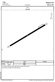
Runways:
| RWY identifier | QFU | Length (ft) | Width (ft) | Surface | LDA (ft) |
| 04 | 59° | 2261 | 40 | ASPH | |
| 22 | 239° | 2261 | 40 | ASPH |
Airport contact information
Address: Tekoa United States