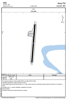


69S - Avey Fld
Located in Laurier, United States
ICAO - 69S, IATA -
Data provided by AirmateGeneral information
Coordinates: N48°59'54" W118°13'21"
Elevation is 1655 feet MSL.
Magnetic variation is 20° East View others Airports in Washington
Operational data
Special qualification required
Current time UTC:
Current local time:
Weather at : CYCG - West Kootenay Regional ( 54 km )
METAR: CYCG 192200Z CCA 35005KT 280V080 15SM SCT085CB SCT120 BKN240 17/00 A2998 RMK CB3AC1CI2 SH DIST SE-S SLP160 DENSITY ALT 2200FT
TAF: TAF CYCG 191840Z 1919/2004 VRB03KT P6SM FEW080 BECMG 1919/1921 35007KT FM192100 35007KT P6SM SCT080 TEMPO 1921/2004 P6SM -SHRA VCTS BKN060CB RMK NXT FCST BY 200100Z
Communications frequencies: [VIEW]
Runways:
| RWY identifier | QFU | Length (ft) | Width (ft) | Surface | LDA (ft) |
| 17 | 185° | 1975 | 40 | GRAVEL | |
| 35 | 5° | 1975 | 40 | GRAVEL |
Airport contact information
Address: Laurier United States