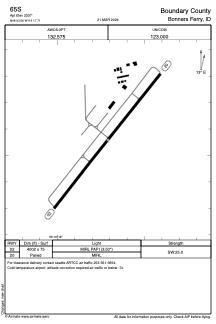


65S - Boundary County
Located in Bonners Ferry, United States
ICAO - 65S, IATA -
Data provided by AirmateGeneral information
Coordinates: N48°43'33" W116°17'43"
Elevation is 2337 feet MSL.
Magnetic variation is 16° East View others Airports in Idaho
Operational data
Special qualification required
Current time UTC:
Current local time:
Communications frequencies: [VIEW]
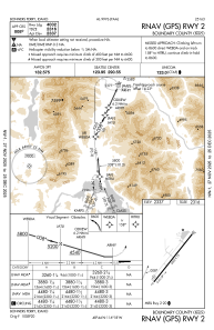
Runways:
| RWY identifier | QFU | Length (ft) | Width (ft) | Surface | LDA (ft) |
| 02 | 38° | 4002 | 75 | ASPH | |
| 20 | 218° | 4002 | 75 | ASPH |
Airport contact information
Address: Bonners Ferry United States
