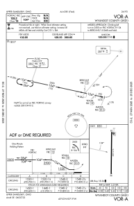
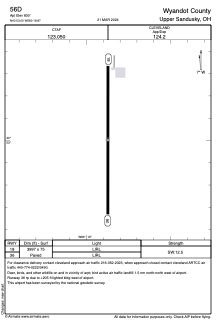


56D - Wyandot County
Located in Upper Sandusky, United States
ICAO - 56D, IATA -
Data provided by AirmateGeneral information
Coordinates: N40°53'0" W83°18'52"
Elevation is 830 feet MSL.
Magnetic variation is -05° East View others Airports in Ohio
Operational data
Special qualification required
Current time UTC:
Current local time:
Communications frequencies: [VIEW]
Runways:
| RWY identifier | QFU | Length (ft) | Width (ft) | Surface | LDA (ft) |
| 18 | 180° | 3997 | 75 | ASPH | |
| 36 | 0° | 3997 | 75 | ASPH |
Airport contact information
Address: Upper Sandusky United States