


53IA - Tama
Located in Tama, United States
ICAO - 53IA, IATA -
Data provided by AirmateGeneral information
Coordinates: N41°56'42" W92°34'45"
Elevation is 814 feet MSL.
Magnetic variation is 03° East View others Airports in Iowa
Operational data
Special qualification required
Current time UTC:
Current local time:
Weather at : KGGI - Grinnell Rgnl ( 29 km )
METAR: KGGI 232355Z AUTO 32016G22KT 10SM CLR 19/02 A2993 RMK AO2 T01870018 10218 20187
Communications frequencies: [VIEW]
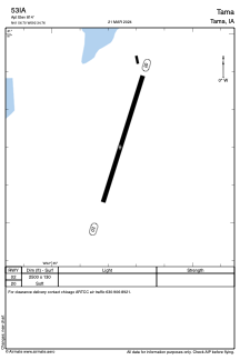
Runways:
| RWY identifier | QFU | Length (ft) | Width (ft) | Surface | LDA (ft) |
| 02 | 18° | 2500 | 130 | GRASS | |
| 20 | 198° | 2500 | 130 | GRASS |
Airport contact information
Address: Tama United States