


50I - Kentland Muni
Located in Kentland, United States
ICAO - 50I, IATA -
Data provided by AirmateGeneral information
Coordinates: N40°45'31" W87°25'45"
Elevation is 699 feet MSL.
Magnetic variation is -04° East View others Airports in Indiana
Operational data
Special qualification required
Current time UTC:
Current local time:
Weather at : KRZL - Jasper County ( 30 km )
METAR: KRZL 250815Z AUTO 04004KT 10SM CLR 00/00 A3034 RMK AO2
Communications frequencies: [VIEW]
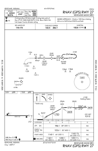
Runways:
| RWY identifier | QFU | Length (ft) | Width (ft) | Surface | LDA (ft) |
| 09 | 90° | 4004 | 60 | CONC | |
| 27 | 270° | 4004 | 60 | CONC |
Airport contact information
Address: Kentland United States