


4O1 - Snyder
Located in Snyder, United States
ICAO - 4O1, IATA -
Data provided by AirmateGeneral information
Coordinates: N34°37'40" W99°0'50"
Elevation is 1325 feet MSL.
Magnetic variation is 08° East View others Airports in Oklahoma
Operational data
Special qualification required
Current time UTC:
Current local time:
Weather at : KLTS - Altus Afb ( 24 km )
METAR: KLTS 270055Z 20012KT 10SM CLR 27/01 A2957 RMK AO2A SLP001 T02710007 $
TAF: TAF KLTS 270100Z 2701/2807 20010KT 9999 SKC QNH2957INS BECMG 2707/2708 17009KT 9999 BKN015 QNH2954INS BECMG 2710/2711 17010G15KT 9999 BKN020 OVC040 QNH2955INS BECMG 2712/2713 18015G25KT 6000 -SHRA VCTS BKN020CB OVC030 QNH2962INS TEMPO 2713/2716 23035G50KT 4800 TSRAGR BKN015CB BECMG 2716/2717 18015G25KT 9999 NSW BKN030 QNH2960INS BECMG 2802/2803 19015G25KT 6000 -SHRA VCTS BKN030CB QNH2961INS TEMPO 2803/2805 27035G50KT 4800 TSRAGR BKN025CB BECMG 2805/2806 26020G30KT 9999 NSW SCT030 BKN050 510003 QNH2965INS TX28/2721Z TN19/2712Z
Communications frequencies: [VIEW]
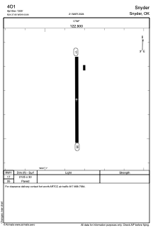
Runways:
| RWY identifier | QFU | Length (ft) | Width (ft) | Surface | LDA (ft) |
| 17 | 179° | 2125 | 30 | ASPH | |
| 35 | 359° | 2125 | 30 | ASPH |
Airport contact information
Address: Snyder United States