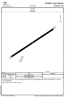


44M - Tenkiller Lake Airpark
Located in Cookson, United States
ICAO - 44M, IATA -
Data provided by AirmateGeneral information
Coordinates: N35°42'18" W94°56'10"
Elevation is 877 feet MSL.
Magnetic variation is 05° East View others Airports in Oklahoma
Operational data
Special qualification required
Current time UTC:
Current local time:
Weather at : KTQH - Tahlequah Muni ( 26 km )
METAR: KTQH 252035Z AUTO 13010G15KT 10SM CLR 24/16 A2990 RMK AO2
Communications frequencies: [VIEW]
Runways:
| RWY identifier | QFU | Length (ft) | Width (ft) | Surface | LDA (ft) |
| 05 | 56° | 2600 | 75 | GRASS | |
| 23 | 236° | 2600 | 75 | GRASS |
Airport contact information
Address: Cookson United States