


44C - Beloit
Located in Beloit, United States
ICAO - 44C, IATA -
Data provided by AirmateGeneral information
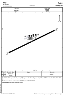
Coordinates: N42°29'52" W88°58'3"
Elevation is 817 feet MSL.
Magnetic variation is -03° East View others Airports in Wisconsin
Operational data
Special qualification required
Current time UTC:
Current local time:
Weather at : KJVL - Southern Wisconsin Rgnl ( 15 km )
METAR: KJVL 070310Z AUTO 09006KT 10SM CLR 15/04 A2983 RMK AO2
TAF: KJVL 070259Z 0703/0724 11010KT P6SM FEW200 FM071000 12012G20KT P6SM BKN030 FM071300 12014G23KT 6SM SHRA BR OVC022 PROB30 0716/0720 4SM TSRA BR OVC015CB FM072000 21011KT P6SM BKN050 FM072100 24010KT P6SM SCT110
Communications frequencies: [VIEW]
Runways:
| RWY identifier | QFU | Length (ft) | Width (ft) | Surface | LDA (ft) |
| 07 | 64° | 3300 | 50 | ASPH | |
| 25 | 244° | 3300 | 50 | ASPH |
Airport contact information
Address: Beloit United States