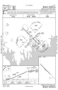
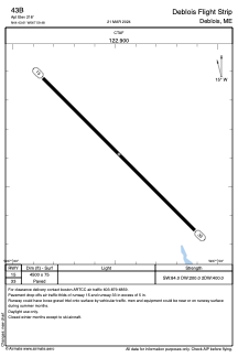


43B - Deblois Flight Strip
Located in Deblois, United States
ICAO - 43B, IATA -
Data provided by AirmateGeneral information
Coordinates: N44°43'37" W67°59'29"
Elevation is 218 feet MSL.
Magnetic variation is -16° East View others Airports in Maine
Operational data
Special qualification required
Current time UTC:
Current local time:
Weather at : KBHB - Hancock County/Bar Harbor ( 43 km )
METAR: KBHB 260756Z AUTO 00000KT 10SM CLR M03/M06 A3042 RMK AO2 SLP302 T10281061 FZRANO
TAF: KBHB 260524Z 2606/2706 VRB03KT P6SM SKC FM261500 33006KT P6SM FEW060 FM261900 20008KT P6SM FEW060 FM262300 VRB03KT P6SM SCT200
Communications frequencies: [VIEW]
Runways:
| RWY identifier | QFU | Length (ft) | Width (ft) | Surface | LDA (ft) |
| 15 | 135° | 4500 | 75 | ASPH | |
| 33 | 315° | 4500 | 75 | ASPH |
Airport contact information
Address: Deblois United States