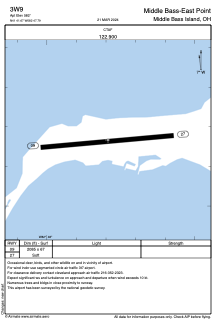


3W9 - Middle Bass-East Point
Located in Middle Bass Island, United States
ICAO - 3W9, IATA -
Data provided by AirmateGeneral information
Coordinates: N41°41'40" W82°47'48"
Elevation is 582 feet MSL.
Magnetic variation is -07° East View others Airports in Ohio
Operational data
Special qualification required
Current time UTC:
Current local time:
Weather at : KPCW - Erie-Ottawa Intl ( 21 km )
METAR: KPCW 232355Z AUTO 24007KT 5SM -RA OVC036 10/09 A2987 RMK AO2 P0004
Communications frequencies: [VIEW]
Runways:
| RWY identifier | QFU | Length (ft) | Width (ft) | Surface | LDA (ft) |
| 09 | 86° | 2085 | 67 | GRASS | |
| 27 | 266° | 2085 | 67 | GRASS |
Airport contact information
Address: Middle Bass Island United States