


3SD4 - Chris Hofer Landing Strip
Located in Tea, United States
ICAO - 3SD4, IATA -
Data provided by AirmateGeneral information
Coordinates: N43°27'55" W96°51'46"
Elevation is 1515 feet MSL.
View others Airports in South Dakota
Operational data
Special qualification required
Current time UTC:
Current local time:
Weather at : KFSD - Joe Foss Fld ( 16 km )
METAR: KFSD 270256Z 08006KT 8SM -RA BKN012 BKN015 OVC055 14/12 A2938 RMK AO2 SLP949 P0004 60007 T01440117 53010
TAF: KFSD 270248Z 2703/2724 06003KT 6SM -RA BKN019 OVC080 FM270400 20011G18KT P6SM -SHRA OVC009 FM270700 26012G19KT P6SM OVC006 FM271400 31011G18KT P6SM OVC012 FM272100 35009KT P6SM BKN018
Communications frequencies: [VIEW]
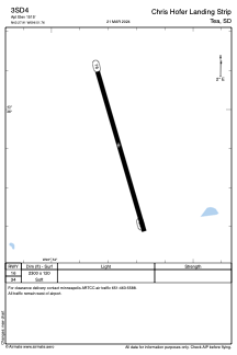
Runways:
| RWY identifier | QFU | Length (ft) | Width (ft) | Surface | LDA (ft) |
| 16 | 164° | 2300 | 120 | GRASS | |
| 34 | 344° | 2300 | 120 | GRASS |
Airport contact information
Address: Tea United States