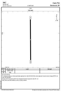


38C - Cain Fld
Located in Stanwood, United States
ICAO - 38C, IATA -
Data provided by AirmateGeneral information
Coordinates: N43°35'54" W85°29'33"
Elevation is 897 feet MSL.
Magnetic variation is -04° East View others Airports in Michigan
Operational data
Special qualification required
Current time UTC:
Current local time:
Weather at : KRQB - Roben-Hood ( 14 km )
METAR: KRQB 200835Z AUTO 29008KT 10SM SCT035 SCT041 OVC065 02/M06 A3002 RMK AO2 T00161061
Communications frequencies: [VIEW]
Runways:
| RWY identifier | QFU | Length (ft) | Width (ft) | Surface | LDA (ft) |
| 18 | 180° | 3472 | 100 | GRASS | |
| 36 | 360° | 3472 | 100 | GRASS |
Airport contact information
Address: Stanwood United States