


33K - Kinsley Muni
Located in Kinsley, United States
ICAO - 33K, IATA -
Data provided by AirmateGeneral information
Coordinates: N37°54'32" W99°24'11"
Elevation is 2171 feet MSL.
Magnetic variation is 08° East View others Airports in Kansas
Operational data
Special qualification required
Current time UTC:
Current local time:
Weather at : KDDC - Dodge City Rgnl ( 52 km )
METAR: KDDC 251752Z AUTO 18021G28KT 7SM SCT029 27/18 A2977 RMK AO2 PK WND 18028/1750 SLP054 T02720178 10272 20161 55017
TAF: KDDC 251720Z 2518/2618 18020G27KT P6SM OVC029 FM252300 16027G37KT P6SM VCTS BKN080CB FM260400 15020G28KT P6SM SCT070
Communications frequencies: [VIEW]
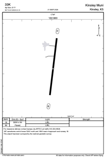
Runways:
| RWY identifier | QFU | Length (ft) | Width (ft) | Surface | LDA (ft) |
| 18 | 187° | 3290 | 56 | ASPH | |
| 36 | 7° | 3290 | 56 | ASPH |
Airport contact information
Address: Kinsley United States