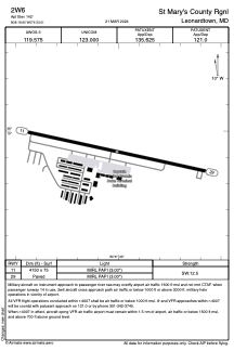


2W6 - St Mary's County Rgnl
Located in Leonardtown, United States
ICAO - 2W6, IATA -
Data provided by AirmateGeneral information
Coordinates: N38°18'55" W76°33'0"
Elevation is 142 feet MSL.
Magnetic variation is -10° East View others Airports in Maryland
Operational data
Special qualification required
Current time UTC:
Current local time:
Weather at : KNHK - Patuxent River Nas (Trapnell Fld) ( 13 km )
METAR: KNHK 061752Z 26007KT 10SM OVC025 24/19 A2997 RMK AO2 SLP149 T02440189 10244 20217 58011 $
TAF: TAF KNHK 0615/0715 26006KT 9999 SCT015 OVC035 QNH2994INS TEMPO 0615/0617 BKN015 OVC035 BECMG 0616/0617 12008KT 9999 BKN040 OVC110 651209 QNH2986INS BECMG 0623/0700 VRB05KT 9999 VCTS SCT010CB OVC030 651209 QNH2979INS TEMPO 0700/0706 VRB20G30KT 1600 TSRA BR OVC006CB BECMG 0705/0706 VRB03KT 9999 NSW BKN005 651208 QNH2978INS TX25/0618Z T18/0710Z FN20065
Communications frequencies: [VIEW]
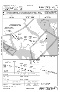
Runways:
| RWY identifier | QFU | Length (ft) | Width (ft) | Surface | LDA (ft) |
| 11 | 102° | 4150 | 75 | ASPH | |
| 29 | 282° | 4150 | 75 | ASPH |
Airport contact information
Address: Leonardtown United States

