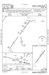
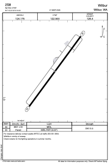


2S8 - Wilbur
Located in Wilbur, United States
ICAO - 2S8, IATA -
Data provided by AirmateGeneral information
Coordinates: N47°45'12" W118°44'38"
Elevation is 2183 feet MSL.
Magnetic variation is 15° East View others Airports in Washington
Operational data
Special qualification required
Current time UTC:
Current local time:
Weather at : KMWH - Grant County Intl ( 74 km )
METAR: KMWH 192352Z AUTO 30005KT 10SM FEW090 19/M02 A3006 RMK AO2 SLP179 T01891017 10200 20156 56008
TAF: KMWH 192320Z 2000/2024 25008G16KT P6SM SCT080 FM200300 31007KT P6SM FEW080 SCT100 FM201000 32005KT P6SM SKC FM201800 27009KT P6SM FEW080
Communications frequencies: [VIEW]
Runways:
| RWY identifier | QFU | Length (ft) | Width (ft) | Surface | LDA (ft) |
| 02 | 36° | 3851 | 60 | ASPH | |
| 20 | 216° | 3851 | 60 | ASPH |
Airport contact information
Address: Wilbur United States