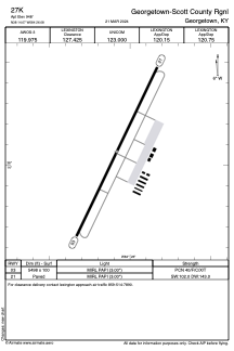


27K - Georgetown-Scott County Rgnl
Located in Georgetown, United States
ICAO - 27K, IATA -
Data provided by AirmateGeneral information
Coordinates: N38°14'4" W84°26'5"
Elevation is 948 feet MSL.
Magnetic variation is -03° East View others Airports in Kentucky
Operational data
Special qualification required
Current time UTC:
Current local time:
Weather at : KLEX - Blue Grass ( 27 km )
METAR: KLEX 020454Z 15005KT 10SM CLR 20/13 A2999 RMK AO2 SLP147 T02000133 402830117
TAF: KLEX 020520Z 0206/0306 15004KT P6SM SCT250 FM021600 18007KT P6SM FEW250 FM030000 16004KT P6SM BKN250
Communications frequencies: [VIEW]
Runways:
| RWY identifier | QFU | Length (ft) | Width (ft) | Surface | LDA (ft) |
| 03 | 26° | 5498 | 100 | ASPH | |
| 21 | 206° | 5498 | 100 | ASPH |
Airport contact information
Address: Georgetown United States
Other aviation service providers
Flight schools

Officer Don Flight Training Academy
Officer Don Flight Training Academy
don@officerdon.com+1(859)422-8727