


24S - Pinehurst State
Located in Pinehurst, United States
ICAO - 24S, IATA -
Data provided by AirmateGeneral information
Coordinates: N42°6'37" W122°22'59"
Elevation is 3643 feet MSL.
Magnetic variation is 18° East View others Airports in Oregon
Operational data
Special qualification required
Current time UTC:
Current local time:
Weather at : KSIY - Siskiyou County ( 37 km )
METAR: KSIY 231453Z AUTO 00000KT 10SM SCT120 09/04 A2990 RMK AO2 SLP129 T00890044 53012
Communications frequencies: [VIEW]
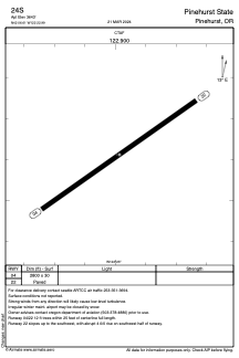
Runways:
| RWY identifier | QFU | Length (ft) | Width (ft) | Surface | LDA (ft) |
| 04 | 55° | 2800 | 30 | ASPH | |
| 22 | 235° | 2800 | 30 | ASPH |
Airport contact information
Address: Pinehurst United States