


24F - Cypress River
Located in Jefferson, United States
ICAO - 24F, IATA -
Data provided by AirmateGeneral information
Coordinates: N32°44'40" W94°18'17"
Elevation is 221 feet MSL.
Magnetic variation is 05° East View others Airports in Texas
Operational data
Special qualification required
Current time UTC:
Current local time:
Communications frequencies: [VIEW]
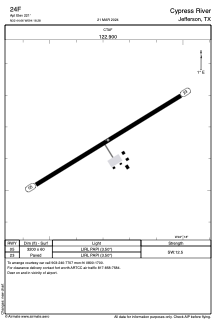
Runways:
| RWY identifier | QFU | Length (ft) | Width (ft) | Surface | LDA (ft) |
| 05 | 59° | 3200 | 60 | ASPH | |
| 23 | 239° | 3200 | 60 | ASPH |
Airport contact information
Address: Jefferson United States