


18I - Mc Creary County
Located in Pine Knot, United States
ICAO - 18I, IATA -
Data provided by AirmateGeneral information
Coordinates: N36°41'43" W84°23'29"
Elevation is 1371 feet MSL.
Magnetic variation is -05° East View others Airports in Kentucky
Operational data
Special qualification required
Current time UTC:
Current local time:
Weather at : KBYL - Williamsburg-Whitley County ( 20 km )
METAR: KBYL 200555Z AUTO 00000KT 10SM OVC036 12/12 A3013 RMK AO1
Communications frequencies: [VIEW]
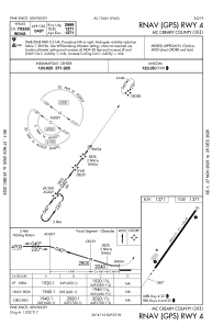
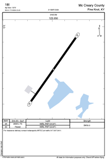
Runways:
| RWY identifier | QFU | Length (ft) | Width (ft) | Surface | LDA (ft) |
| 04 | 35° | 2999 | 75 | ASPH | |
| 22 | 215° | 2999 | 75 | ASPH |
Airport contact information
Address: Pine Knot United States