


17K - Boise City
Located in Boise City, United States
ICAO - 17K, IATA -
Data provided by AirmateGeneral information
Coordinates: N36°46'28" W102°30'38"
Elevation is 4174 feet MSL.
Magnetic variation is 09° East View others Airports in Oklahoma
Operational data
Special qualification required
Current time UTC:
Current local time:
Weather at : KEHA - Elkhart-Morton County ( 61 km )
METAR: KEHA 240335Z AUTO 09006KT 10SM CLR 11/01 A3016 RMK AO2 T01140009
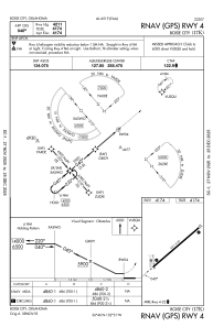
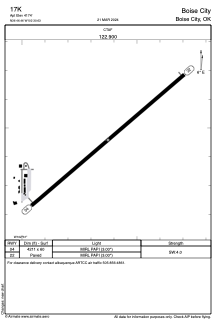
Communications frequencies: [VIEW]
Runways:
| RWY identifier | QFU | Length (ft) | Width (ft) | Surface | LDA (ft) |
| 04 | 49° | 4211 | 60 | ASPH | |
| 22 | 229° | 4211 | 60 | ASPH |
Airport contact information
Address: Boise City United States