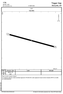


17A - Trigger Gap
Located in Berryville, United States
ICAO - 17A, IATA -
Data provided by AirmateGeneral information
Coordinates: N36°19'42" W93°37'20"
Elevation is 1650 feet MSL.
View others Airports in Arkansas
Operational data
Special qualification required
Current time UTC:
Current local time:
Weather at : KHRO - Boone County ( 43 km )
METAR: KHRO 260053Z AUTO 12010KT 3/4SM BR VV002 11/11 A3003 RMK AO2 SLP166 T01110111
TAF: KHRO 252320Z 2600/2624 13013KT 6SM -SHRA VCSH OVC008 TEMPO 2600/2604 1/2SM FG BKN002 FM261500 16014KT 6SM -TSRA BR OVC015CB WS020/18045KT FM261800 16018G25KT 4SM -RA BR OVC007
Communications frequencies: [VIEW]
Runways:
| RWY identifier | QFU | Length (ft) | Width (ft) | Surface | LDA (ft) |
| 10 | 105° | 3000 | 75 | GRASS | |
| 28 | 285° | 3000 | 75 | GRASS |
Airport contact information
Address: Berryville United States