


12K - Superior Muni
Located in Superior, United States
ICAO - 12K, IATA -
Data provided by AirmateGeneral information
Coordinates: N40°2'46" W98°3'41"
Elevation is 1692 feet MSL.
Magnetic variation is 05° East View others Airports in Nebraska
Operational data
Special qualification required
Current time UTC:
Current local time:
Weather at : KHJH - Hebron Muni ( 42 km )
METAR: KHJH 230755Z AUTO 03006KT 10SM -RA SCT100 SCT120 13/10 A2978 RMK AO2 LTG DSNT E W AND NW P0003 T01340100
Communications frequencies: [VIEW]
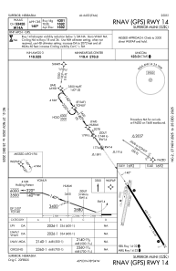
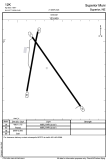
Runways:
| RWY identifier | QFU | Length (ft) | Width (ft) | Surface | LDA (ft) |
| 14 | 145° | 4301 | 75 | CONC | |
| 32 | 325° | 4301 | 75 | CONC | |
| 18 | 190° | 2999 | 200 | GRASS | |
| 36 | 10° | 2999 | 200 | GRASS |
Airport contact information
Address: Superior United States