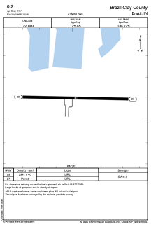


0I2 - Brazil Clay County
Located in Brazil, United States
ICAO - 0I2, IATA -
Data provided by AirmateGeneral information
Coordinates: N39°28'36" W87°5'59"
Elevation is 645 feet MSL.
Magnetic variation is -04° East View others Airports in Indiana
Operational data
Special qualification required
Current time UTC:
Current local time:
Weather at : KHUF - Terre Haute Rgnl ( 18 km )
METAR: KHUF 071153Z 14010KT 10SM CLR 19/19 A2970 RMK AO2 LTG DSNT E RAE03 SLP053 P0000 60014 70014 T01940189 10194 20178 56012
TAF: KHUF 071120Z 0712/0812 16011G20KT P6SM VCTS OVC070CB FM071300 16012G22KT 6SM SHRA BR VCTS OVC035CB FM071400 18012G23KT 6SM SHRA BR VCTS OVC023CB FM071600 18014G24KT P6SM VCTS OVC015CB FM072100 21015G25KT P6SM VCTS BKN023CB FM072300 23011G21KT P6SM SCT030
Communications frequencies: [VIEW]
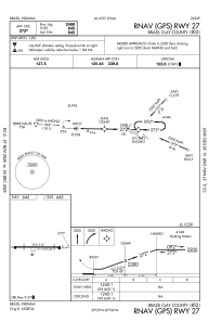
Runways:
| RWY identifier | QFU | Length (ft) | Width (ft) | Surface | LDA (ft) |
| 09 | 91° | 2941 | 40 | ASPH | |
| 27 | 271° | 2941 | 40 | ASPH |
Airport contact information
Address: Brazil United States