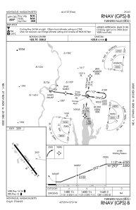
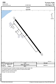


0B5 - Turners Falls
Located in Montague, United States
ICAO - 0B5, IATA -
Data provided by AirmateGeneral information
Coordinates: N42°35'30" W72°31'23"
Elevation is 359 feet MSL.
Magnetic variation is -15° East View others Airports in Massachusetts
Operational data
Special qualification required
Current time UTC:
Current local time:
Weather at : KORE - Orange Muni ( 19 km )
METAR: KORE 250452Z AUTO 35006KT 10SM CLR M01/M04 A3019 RMK AO2 SLP229 T10061044 401781011
Communications frequencies: [VIEW]
Runways:
| RWY identifier | QFU | Length (ft) | Width (ft) | Surface | LDA (ft) |
| 16 | 143° | 3200 | 75 | ASPH | |
| 34 | 323° | 3200 | 75 | ASPH |
Airport contact information
Address: Montague United States
