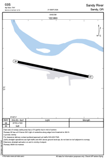


03S - Sandy River
Located in Sandy, United States
ICAO - 03S, IATA -
Data provided by AirmateGeneral information
Coordinates: N45°24'6" W122°13'43"
Elevation is 704 feet MSL.
Magnetic variation is 19° East View others Airports in Oregon
Operational data
Special qualification required
Current time UTC:
Current local time:
Weather at : KTTD - Portland-Troutdale ( 21 km )
METAR: KTTD 040453Z 08004KT 9SM -RA SCT041 BKN055 OVC070 13/11 A2972 RMK AO2 SLP064 P0003 T01280111
TAF: KTTD 040520Z 0406/0506 10005KT P6SM -RA BKN045 OVC070 FM040800 VRB04KT 5SM RA BR BKN035 OVC060 FM041100 23008KT 4SM RA BR SCT007 OVC020 FM050300 23008KT 5SM RA BR OVC021
Communications frequencies: [VIEW]
Runways:
| RWY identifier | QFU | Length (ft) | Width (ft) | Surface | LDA (ft) |
| 08 | 101° | 2115 | 100 | GRASS | |
| 26 | 281° | 2115 | 100 | GRASS |
Airport contact information
Address: Sandy United States