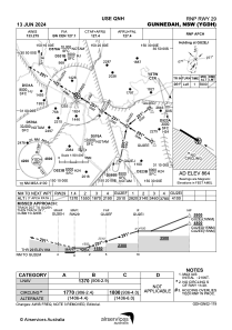
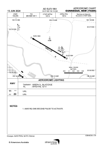


YGDH - Gunnedah
Located in Gunnedah, Australia
ICAO - YGDH, IATA - GUH
Data provided by AirmateGeneral information
Coordinates: S30°57'40" E150°15'2"
Elevation is 863 feet MSL.
View others Airports in New South Wales
Operational data
Special qualification required
Current time UTC:
Current local time:
Communications frequencies: [VIEW]
Runways:
| RWY identifier | QFU | Length (ft) | Width (ft) | Surface | LDA (ft) |
| 11 | 123° | 5400 | 98 | ASP | |
| 29 | 303° | 5400 | 98 | ASP |
Airport contact information
Address: Gunnedah Australia
