logo
Search for airport 
image banner adimage banner adimage banner ad
image banner ad

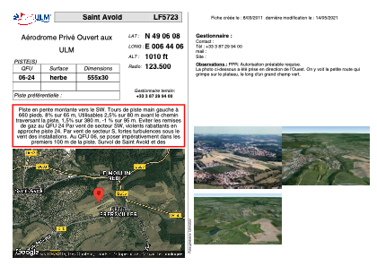
LF5723 - Saint Avold

Located in Macheren, France

ICAO - , IATA -

Data provided by Airmate  

General information

Coordinates: N49°6'8" E6°44'6"
Elevation is 1010 feet MSL.
 
View others Airports in Lorraine

Operational data

Special qualification required
Current time UTC:
Current local time:
Weather at : EDDR - Saarbruecken ( 30 km )
METAR: EDDR 230550Z AUTO 22004KT 190V260 0400 R09/0750U FG VV002 11/10 Q1016 BECMG 3000 BCFG SCT002
TAF: TAF EDDR 230500Z 2306/2406 22004KT 0300 FG VV001 BECMG 2306/2308 9999 SCT015 PROB40 TEMPO 2310/2319 24015G25KT TSRA SCT025CB TEMPO 2400/2406 1500 -RA BR BKN001
View NOTAMs / SUP AIP / TFR affecting this airport [VIEW]
Communications frequencies: [VIEW]

Runways:

RWY identifierQFULength (ft)Width (ft)SurfaceLDA (ft)
06182098GRASS
24182098GRASS

Airport contact information

Address: Macheren France

Other aviation service providers

Aviation club (not for profit)

Aéroclub de St Avold

Aéroclub de St Avold

Satellite view of LF5723