


KPIA - General Downing - Peoria Intl
Located in Peoria, United States
ICAO - PIA, IATA - PIA
Data provided by AirmateGeneral information
Coordinates: N40°39'51" W89°41'36"
Elevation is 660 feet MSL.
Magnetic variation is -02° East View others Airports in Illinois
Operational data
Special qualification required
Current time UTC:
Current local time:
Communications frequencies: [VIEW]
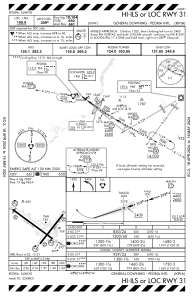
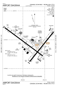
Runways:
| RWY identifier | QFU | Length (ft) | Width (ft) | Surface | LDA (ft) |
| 04 | 39° | 8004 | 150 | ASPH | 7826 |
| 22 | 219° | 8004 | 150 | ASPH | 8004 |
| 13 | 127° | 10104 | 150 | CONC | 9604 |
| 31 | 307° | 10104 | 150 | CONC | 10104 |
Airport contact information
Address: Peoria United States
