


KDAF - Necedah
Located in Necedah, United States
ICAO - DAF, IATA -
Data provided by AirmateGeneral information
Coordinates: N44°2'0" W90°5'6"
Elevation is 919 feet MSL.
Magnetic variation is -01° East View others Airports in Wisconsin
Operational data
Special qualification required
Current time UTC:
Current local time:
Communications frequencies: [VIEW]
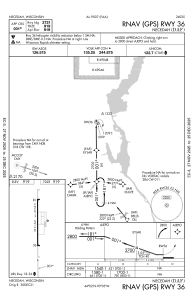
Runways:
| RWY identifier | QFU | Length (ft) | Width (ft) | Surface | LDA (ft) |
| 18 | 179° | 2721 | 60 | ASPH | |
| 36 | 359° | 2721 | 60 | ASPH |
Airport contact information
Address: Necedah United States