


ID57 - Red Bird
Located in Lewiston, United States
ICAO - ID57, IATA -
Data provided by AirmateGeneral information
Coordinates: N46°13'23" W116°52'12"
Elevation is 2996 feet MSL.
View others Airports in Idaho
Operational data
Special qualification required
Current time UTC:
Current local time:
Communications frequencies: [VIEW]
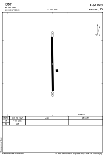
Runways:
| RWY identifier | QFU | Length (ft) | Width (ft) | Surface | LDA (ft) |
| 17 | 0° | 1484 | 65 | GRASS | |
| 35 | 0° | 1484 | 65 | GRASS |
Airport contact information
Address: Lewiston United States