logo
Search for airport 
image banner adimage banner adimage banner ad
image banner ad

CSU3 - St-Hyacinthe

Located in , Canada

ICAO - CSU3, IATA -

Data provided by Airmate  

General information

Coordinates: N45°36'24" W73°0'54"
Elevation is 118 feet MSL.
Magnetic variation is -16° East
View others Airports in Quebec

Operational data

Special qualification required
Current time UTC:
Current local time:
Weather at : CYHU - St-Hubert ( 33 km )
METAR: CYHU 152300Z AUTO 36007KT 320V030 9SM CLR 20/03 A3008 RMK SLP189 DENSITY ALT 500FT
TAF: TAF CYHU 151740Z 1518/1618 33010G20KT P6SM FEW040 BECMG 1522/1524 33008KT FM161000 VRB03KT P6SM SKC BECMG 1615/1617 17008KT RMK FCST BASED ON AUTO OBS. NXT FCST BY 160000Z
View NOTAMs / SUP AIP / TFR affecting this airport [VIEW]
Communications frequencies: [VIEW]
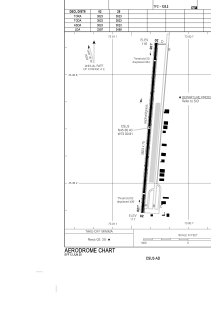
Runways:

RWY identifierQFULength (ft)Width (ft)SurfaceLDA (ft)
02382375ASP+GRS3397
20185°382375ASP+GRS3469

Airport contact information

Address: Canada

Other aviation service providers

Flight schools

Aviation Rou-Air

Aviation Rou-Air
info@rouair.com+15146086018

Gyro Aventure

Gyro Aventure

Satellite view of CSU3