WAFU - Ampana / Tanjung Api
Located in Ampana, Indonesia
ICAO - , IATA -
Data provided by AirmateGeneral information
Coordinates: S0°51'50" E121°37'30"
Elevation is 107 feet MSL.
View others Airports in Sulawesi Tengah
Operational data
Special qualification required
Current time UTC:
Current local time:
Weather at : WAMW - Watusongo ( 33 km )
METAR: Data unavailable at the moment
TAF: Data unavailable at the moment
Communications frequencies: [VIEW]
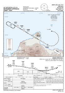
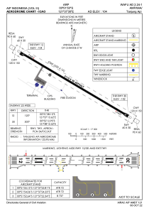
Runways:
| RWY identifier | QFU | Length (ft) | Width (ft) | Surface | LDA (ft) |
| 12 | 120° | 6923 | 98 | UNK | |
| 30 | 300° | 6923 | 98 | UNK |
Airport contact information
Address: Ampana Indonesia